
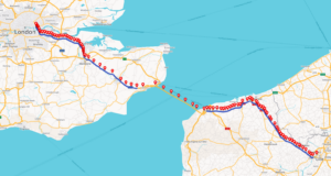
You’re sending a truck from Paris to London and would like to calculate the actual toll costs and emissions for the trip afterward. The GPS tracker recorded positions the whole way. You run those positions through track matching and instead of one continuous track, you get two separate pieces: a line through France, a line through England, and nothing where the Channel should be.
What’s new: Closing Gaps in Track Matching
That gap was not due to missing data. Track matching tries to snap the recorded GPS positions onto the road network, and if no road connection could be established between two positions like in the ferry case, the track-matching process simply split the result.
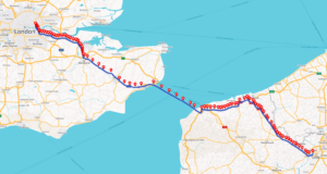
Track matching now bridges those gaps. When it encounters a gap between two matched positions, it fills it in and returns one complete geometry. The same mechanism closes the gaps at complex junctions that, in rare cases, could also lead to interruptions in the past.
What this means in practice
Nothing changes in the API: same request, same fields, one continuous track. Toll reporting, emission calculations, and fleet management all depend on a complete, drivable geometry, and with the track now coming back in one piece, there is less manual work involved and your reports contain more accurate figures.